

Ignition Sources
- 04 Aug 2026
- 5 Minutes to read
Ignition Sources
- Updated on 04 Aug 2026
- 5 Minutes to read
Article summary
Did you find this summary helpful?
Thank you for your feedback!
The Ignition Sources node in RISKCURVES is used to define potential ignition sources for flammable cloud scenarios. This allows delayed ignition to be calculated based on the location and properties of ignition sources in relation to the dispersing flammable cloud.
Ignition is an important part of risk calculations involving flammable substances. A flammable cloud may ignite immediately at the release location, ignite after travelling some distance, or disperse without ignition. These outcomes can lead to different hazardous phenomena, such as jet fires, pool fires, fireballs, flash fires, or vapour cloud explosions.
In RISKCURVES, ignition can be considered in two ways:
- Direct ignition, where ignition occurs at or near the release point. In this case, the release typically follows an immediate jet fire, pool fire, or fireball, depending on the release type and substance.
- Delayed ignition, where the flammable cloud first disperses away from the release point and then ignites after encountering an ignition source. This event path is associated with flammable cloud consequences, such as a flash fire or vapour cloud explosion.
Direct ignition is handled as before because ignition at or near the release point usually results in immediate fire phenomena, such as a jet fire, pool fire, or fireball. The Ignition Sources node is used for delayed ignition, where a flammable cloud disperses first and may later ignite if it encounters an ignition source.
When to use ignition sources
The Ignition Sources functionality can be used when the location of ignition sources is expected to influence the delayed ignition probability and the resulting risk contours.
This can be useful when modelling sites where ignition sources are not distributed uniformly. Examples include industrial sites with process units, railways, parking areas, populated areas, or other specific locations where ignition may occur.
If no ignition sources are defined, RISKCURVES uses the existing delayed ignition approach. In this case, a flash fire is assumed when the cloud is within the flammability limits, according to the defined delayed ignition probability. The ignition is not linked to a specific ignition source location.
When ignition sources are defined, ignition only occurs where the flammable part of the cloud overlaps geographically with a defined ignition source. The delayed ignition probability is then based on the source properties and the duration of the cloud–source interaction. This means that ignition probability becomes dependent on the wind direction, cloud movement, and local site layout. The height of ignition points is assumed to be at ground level.
Types of ignition sources
RISKCURVES supports three types of ignition sources:
- Point
- Line
- Area
Each type is used to represent a different type of ignition source geometry.
Point ignition sources
A point ignition source represents a discrete ignition location. Examples include:
- electrical equipment;
- vehicles;
- hot-work locations;
- other individual ignition sources.
For a point ignition source, the user defines the location of the source, the presence factor, and the ignition probability.
Line ignition sources
A line ignition source represents ignition potential along a linear feature. Examples include:
- electrical lines;
- railways;
- heated pipes;
- other linear ignition sources.
For a line ignition source, the user defines the line geometry and the ignition probability per unit length.
If the ignition probability is not constant along the full line, multiple line ignition sources can be added with different input values.
Area ignition sources
An area ignition source represents a zone where ignition sources are distributed over an area. Examples include:
- process units;
- storage yards;
- parking areas;
- residential areas;
- other populated or industrial zones.
For an area ignition source, the user defines the area geometry and the ignition probability per unit area.
Adding ignition sources
Ignition sources are added in the Ignition Sources node under the calculation set.
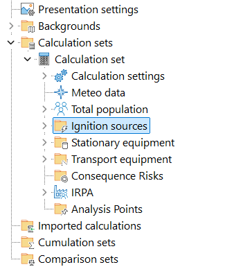 Location of ignition sources node in RISKCURVES To add an ignition source:
- Select the Ignition Sources node.
- Right-click the node.
- Select the type of ignition source to add
- Define the required input parameters.
- Define the location or geometry of the ignition source on the map.
Defining a point ignition source
A point ignition source can be defined by entering its coordinates or by setting the point directly on the map.
.gif) Defining ignition point
Defining ignition point
The main input parameters are:
- Presence factor
- Ignition probability
- Location
The presence factor represents the probability that the ignition source is present or active when the flammable cloud passes. The ignition probability defines the probability that the source ignites the flammable cloud when exposed.
Defining a line ignition source
A line ignition source is defined by drawing a line on the map. To define the geometry:
- Select the line ignition source.
- Click Edit.
- Click on the map to define the first point of the line.
- Click again to define the next point.
- Add more points if the line changes direction.
- Click Done when the line is complete.
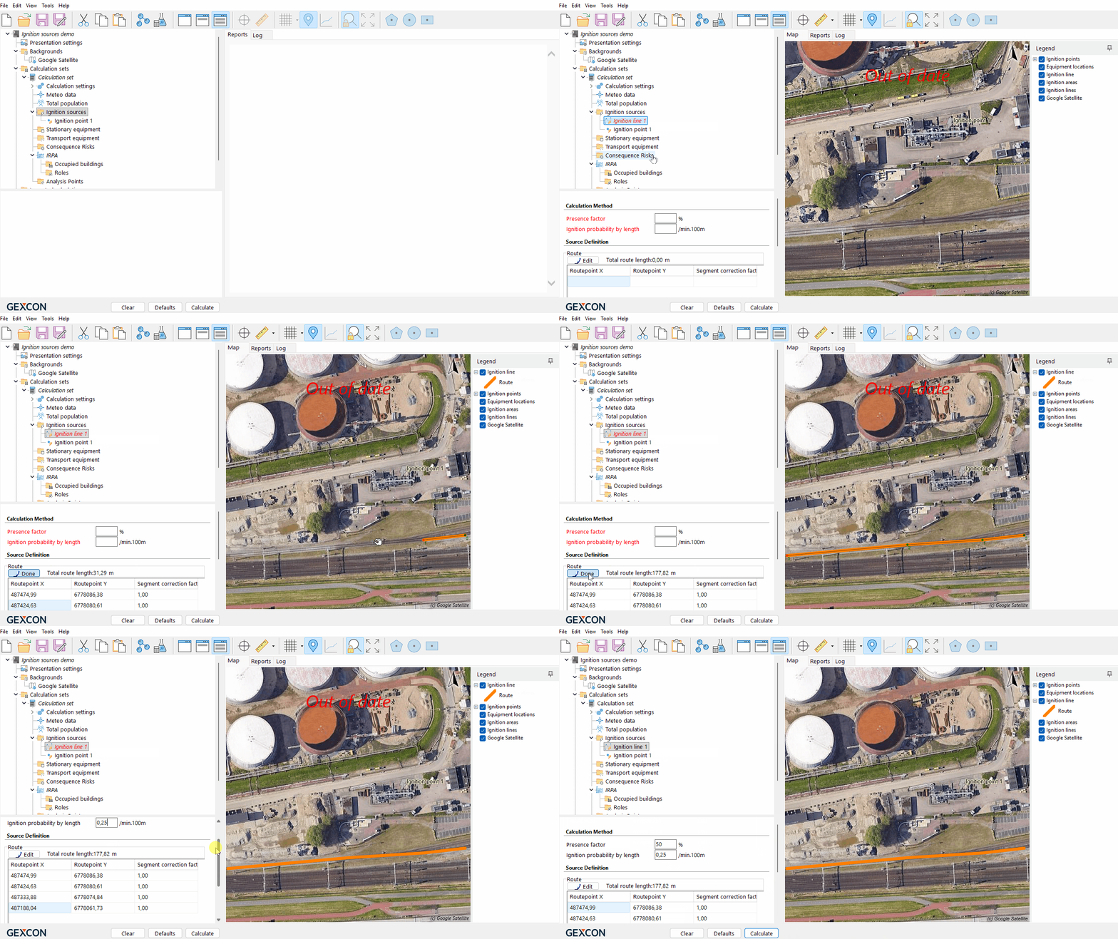 Defining ignition line
The ignition probability for a line source is defined per unit length.
Defining an area ignition source
An area ignition source is defined by drawing a polygon on the map. To define the geometry:
- Select the area ignition source.
- Click Edit.
- Click on the map to define the corner points of the area.
- Define at least three corner points.
- Click Done when the area is complete.
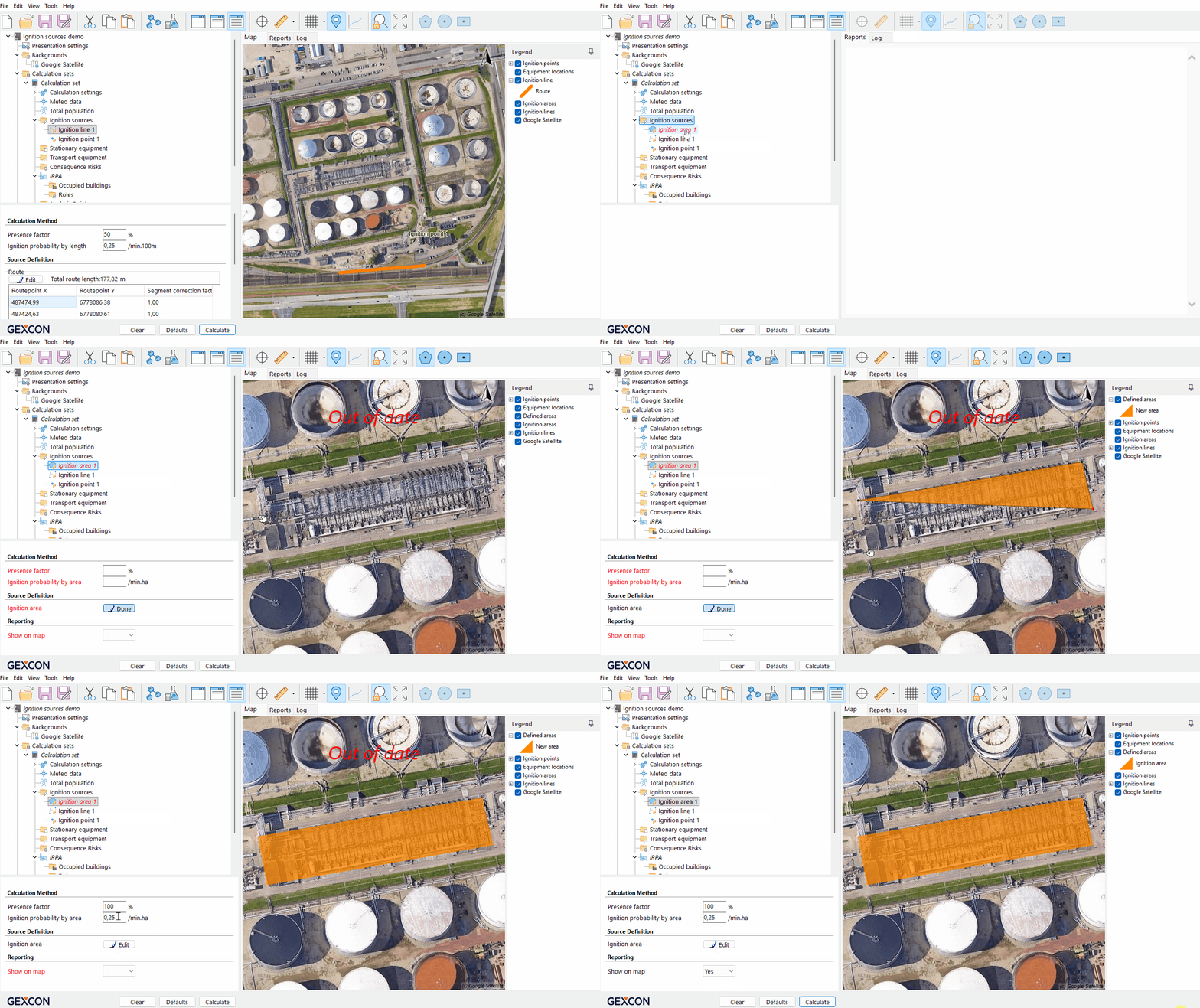 Defining ignition area
The ignition probability for an area source is defined per unit area.
Calculating with ignition sources
During the calculation, RISKCURVES evaluates the flammable cloud footprint for the relevant wind directions and weather conditions. The software checks whether the flammable cloud overlaps with any defined ignition sources. If overlap occurs, the delayed ignition probability is calculated based on the ignition source properties and the exposure time of the flammable cloud to the ignition source.
This means that delayed ignition is no longer represented only by a general probability. Instead, it depends on where the flammable cloud travels and which ignition sources it encounters.
Ignition sources are only relevant for scenarios that produce a flammable cloud. They do not affect scenarios where delayed ignition is not applicable.
Effect on risk results
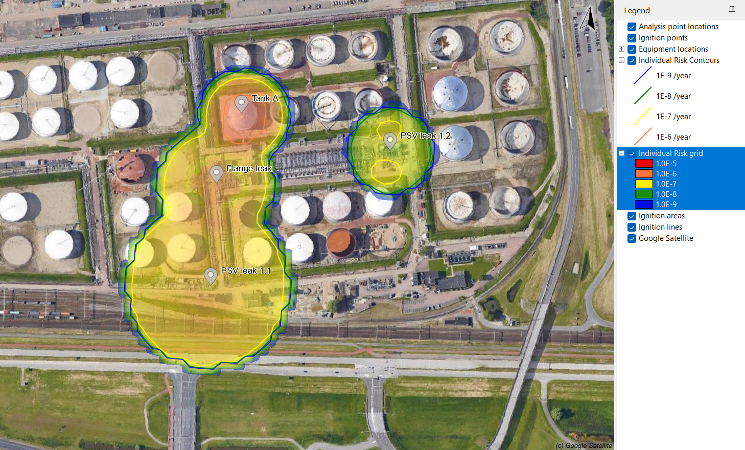
Using ignition sources can change the calculated risk results compared with using a single delayed ignition probability. When ignition sources are defined:
- ignition probability becomes location dependent;
- delayed ignition occurs only when the flammable cloud overlaps with an ignition source;
- the calculated risk may vary more strongly with wind direction;
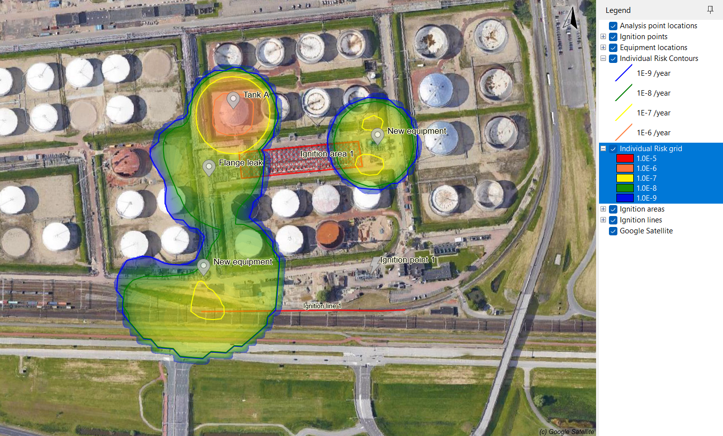
- risk contours may become asymmetric;
- ignition may occur earlier if the flammable cloud reaches a highly effective ignition source;
- downstream risk may decrease if the flammable cloud ignites before dispersing further.
| Individual risk without ignition sources | Individual risk with ignition sources |
 |  |
Example interpretation
Without ignition sources, RISKCURVES applies a general delayed ignition probability. This means that delayed ignition is not linked to a specific location on the map.
With ignition sources, delayed ignition depends on the interaction between the flammable cloud and the defined ignition sources. For example, if a flammable cloud travels towards a railway, or process area defined as an ignition source, the probability of ignition may increase in that direction. If the flammable cloud travels in a direction without ignition sources, delayed ignition may be less likely.
As a result, the calculated risk contours may shift or become asymmetric. This is expected behaviour, as the calculation now reflects the local distribution of ignition sources.
Was this article helpful?